

The Government has just released the new Metropolitan Strategy with a new name “A Plan For Growing Sydney” and ultimately plans for more growth and includes mention of a second airport.
The Strategy sets out four overarching Goals:
- A competitive economy with world class services and transport
- A city of housing choice, with homes that meet our needs and lifestyles
- A great place to live with communities that are strong, healthy and well connected
- A sustainable and resilient city that protects the natural environment and has a balanced approach to the use of land and resources
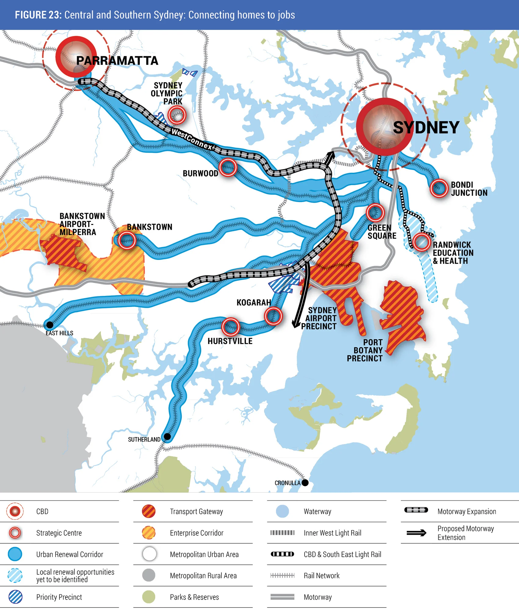
There is a greater focus on Parramatta and Western Sydney in delivering a world class competitive economy through the Global Economic Corridor which is being extended to Parramatta, Norwest and Sydney Olympic Park. A new intense economic hub is proposed around Badgerys Creek and growth in Penrith, Liverpool and Campbelltown- Macarthur coming from improved transport connections to the rest of Sydney.
For further reading go Your Future Sydney
New Parramatta Rd is a program to renew the urban corridor from the Sydney CBD to the City of Parramatta. The corridor connects 10 Local Government Areas that are home to almost one million people.
The Parramatta Road Urban Renewal Program looks to the needs of future generations. It will:
- Create new connections between the communities along Parramatta Road
- Provide housing choice for buyers and renters
- Improve public and active transport connections
- Enhance the road network
- Generate jobs, especially in the West
- Make for a healthier environment.
The strategy proposes that the renewal will be focused in eight strategic Precincts located at Granville, Auburn, Homebush, Burwood, Kings Bay (part of Five Dock), Taverners Hill, Leichhardt and Camperdown.
Following feedback, a final Strategy and Integrated Land Use and Transport Concept will be adopted, the timing of which could be by the end of 2015. Allowing for a further planning implementation phase, the first new development not already in the pipeline could be expected to commence in 2018.
For further information click here to The New Parramatta Road website.
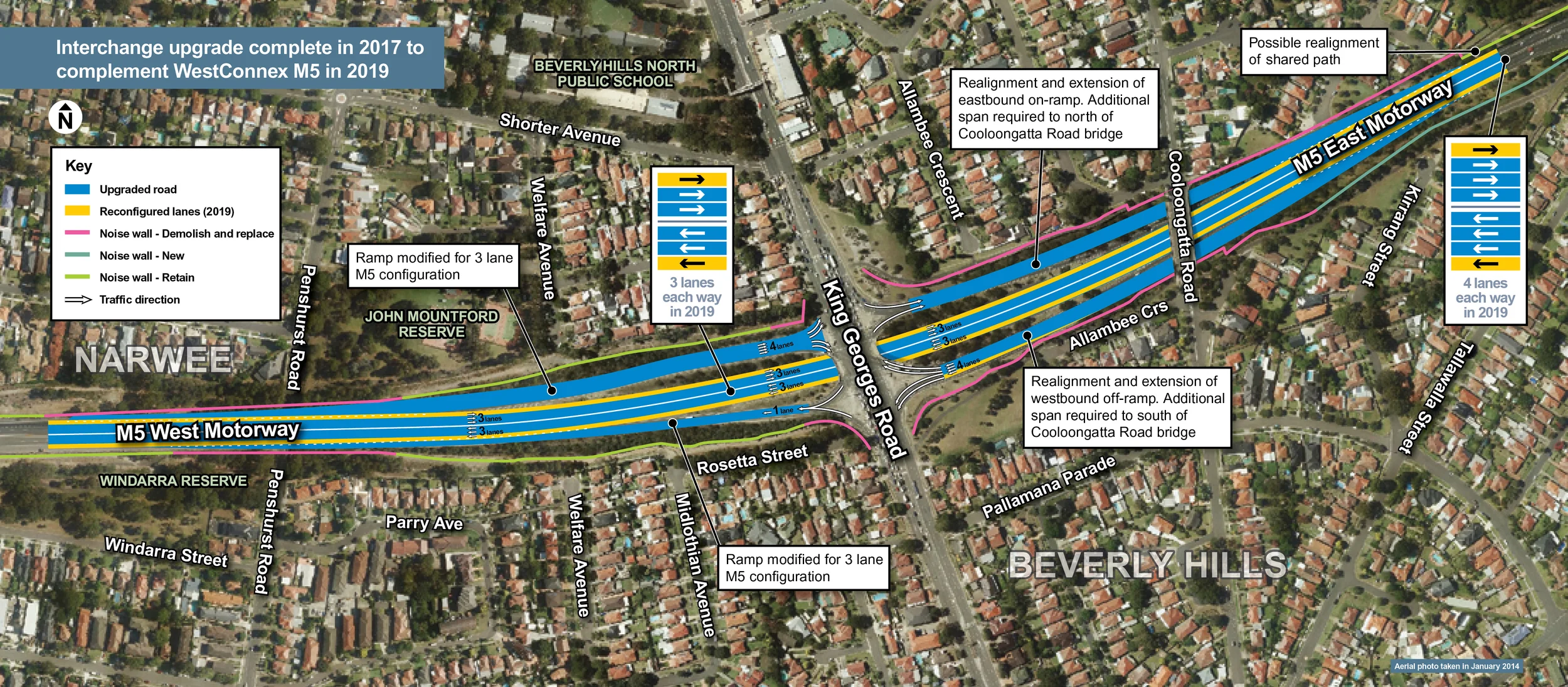
The Australian and NSW Governments are moving ahead with delivering WestConnex Stage 2, lodging the planning application for higher, wider, flatter and future-proofed tunnels to end the daily battle on the M5 East.
The new tunnels will more than double capacity of the M5 East, with the New M5 tunnels built to accommodate three lanes in each direction and provide another route for traffic from the airport and port precinct to Western and South Western Sydney.
The New M5 will link to a major interchange to be built on a landfill site at St Peters which avoids the need for major residential acquisitions and limits impacts on green space.
The St Peters Interchange will provide access to key roads in the area, such as Euston Road and Campbell Street and the project will include widening these roads as well as a new bridge over Alexandra Canal to Bourke Road. The St Peters Interchange will provide access to the Sydney Airport and Port Botany precincts from South Western and Western Sydney once WestConnex is completed.
For more information go to http://www.westconnex.com.au/explore_the_route/stage_2/index.html
Council has prepared a draft development control plan (DCP) which applies to the whole municipality, including all residential areas and business centres.
The Draft DCP carries over controls from the existing DCPs, but also includes some significant changes to existing policy and substantial new policy for some matters.
Some of these changes include:
- New building envelope and floorplate controls that will apply to dwelling houses, semi detached dwellings, dual occupancies and attached dwellings in most residential suburbs. These controls will replace the floor space ratios used in the current Woollahra Residential DCP 2003 for those building types.
- Additional controls in the Paddington Heritage Conservation Area (HCA) for Oxford Street and William Street, as well as for single storey buildings and timber buildings throughout the HCA.
- Various additional controls and modified controls for the Watsons Bay and Woollahra HCAs.
- Additional excavation controls for most residential areas to limit impacts to adjoining and adjacent properties.
- New flood and stormwater controls to limit the impacts of potential flooding in areas including Double Bay, Rose Bay and harbour foreshore localities.
- New controls for pubs, small bars, restaurants and other businesses that require a licence under the Liquor Act 2007. The controls seek to achieve a more consistent approach to determining trading hours and operating conditions.
- Additional signage controls including controls on the extent of external painting of a building in corporate colours in order to minimise the potential negative impact on the streetscape.
Fo further details visit Woollahra Councils website at http://www.woollahra.nsw.gov.au/yourplan/draft_wdcp_2014
The Minister for Planning Pru Goward and Minister for the Illawarra John Ajaka announced on 9 October the release of the Draft Illawarra Regional Growth and Infrastructure Plan.
The draft plan follows extensive community consultation, and it aims to expand the region’s economy to create new jobs close to home and form the blueprint for future planning for the region.
The draft plan sets out six key areas of action:
1. Transforming places
An urban renewal plan for the Wollongong Centre will be developed with a key focus on integrating transport between the University, the Hospital and the City Centre. Further work to be undertaken in northern Illawarra to improve liveability in the Northern Growth Corridor. In the southern Illawarra the draft Plan will coordinate opportunities for new growth. The Maldon Dombarton rail corridor will be protected as part of an international trade gateway action plan.
2. Developing a prosperous Illawarra
The draft Plan makes growing the economy a priority –maximising opportunities coming from Port Kembla, the University of Wollongong and Wollongong Hospital. An economic action plan will be developed to leverage existing and new opportunities through the on-going development of Port Kembla and to attract new businesses and industries.
3. Meeting demand for housing
The draft Plan continues to ensure that there is a wide-range of homes available in West Lake Illawarra and Nowra-Bomaderry through the coordination of land release and infrastructure. There will also be opportunities for new housing in other smaller release areas across the Region.
4. Providing the infrastructure necessary for the Illawarra’s growth
Infrastructure plans will be developed for the new release areas of West Lake Illawarra and Nowra-Bomaderry in the short term. Strategic investment in the region’s infrastructure will continue to be a priority for the NSW Government.
5. Managing the Illawarra’s agriculture and natural resources
Measures will be put in place to better manage agricultural and natural resources including the protection of drinking water catchment areas, strategic biodiversity assessment of Dunmore Hills and mapping regionally significant agricultural land.
6. Managing the Illawarra’s environment and heritage
The draft Plan maps significant heritage and environmental areas in the region to ensure that appropriate controls are in place for new housing and employment land. Work will continue to protect environmentally significant areas of West Dapto and Nowra Bomaderry.
The draft plan is available for viewing and comment at www.planning.nsw.gov.au/illawarra
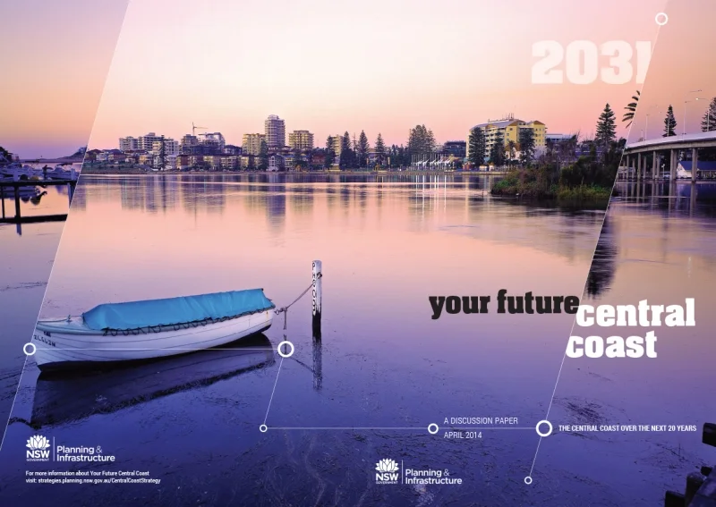
The NSW Government is embarking on a partnership with Central Coast communities that will help shape and define the region’s future.
The Minister for Planning Pru Goward and Minister for the Central Coast and Assistant Minister for Planning Rob Stokes launched on 19 September the Department of Planning and Environment’s discussion paper Your Future Central Coast to kick start the conversation about the Coast’s future, in particular the focus on creating more jobs closer to home.
The discussion paper raises key issues facing the Coast into the future and asks the community for their ideas on how to:
- Build more houses to meet future demand
- Deliver more jobs to meet the region’s needs
- Improve rail and road access to the region
- Balance growth with the protection of the region’s environment
- Protect the lifestyle residents and visitors enjoy.
Residents will have the opportunity to provide feedback on the discussion paper in a range of ways, including submitting ideas online and via social media or taking part in community surveys.
The Central Coast discussion paper is on exhibition until 16 November 2014 and can be viewed at www.planning.nsw.gov.au/onexhibition
Planning and Environment is undertaking a comprehensive review of State Environmental Planning Policy No 65 – Design Quality of Residential Flat Development (SEPP 65) and the Residential Flat Design Code.
A summary of the key features of the proposed amendments include:
- Amendment so that SEPP 65 will apply to residential flat buildings, shop top housing and mixed use developments that include apartments.
- Three clear reasons why consent authorities cannot refuse a DA if it complies with the design guide for ceiling heights, apartment size (existing) and car parking (new).
- Renaming the Residential Flat Design Code the ‘Apartment Design Guide’ to be used as a guideline to be applied flexibly.
- Key parts of the Apartment Design Guide will prevail over council Development Control Plans to remove conflicts.
- The Apartment Design Guide is outcome based and focuses on performance criteria.
- Car parking requirements have been reduced in accessible locations to improve feasibility.
- Confirm that residential flat building applications need to comply with BASIX .
- Delegation to councils to set up design review panels and amended fees that councils can collect.
- Introduce a minimum size for studio apartments.
- Clearer alternative solutions to specific performance criteria.
- Clearer and fairer guidance about assessing privacy and building separation.
- Clearer design advice for natural ventilation and daylight.
- Proposed education and support program to ensure that the SEPP and guideline are used consistently.
Some specific amendments include:
- Ensuring every new apartment has a balcony and access to well designed and functional shared open space.
- Allowing no car spaces in new apartment buildings in certain council areas* within 400 metres of a transport hub like a train station or light rail stop.
- More flexibility around design to suit particular sites.
- A minimum size of 35sqm for studio apartments.
- New sections dealing with the adaptive reuse of buildings to apartments.
For more information go to:
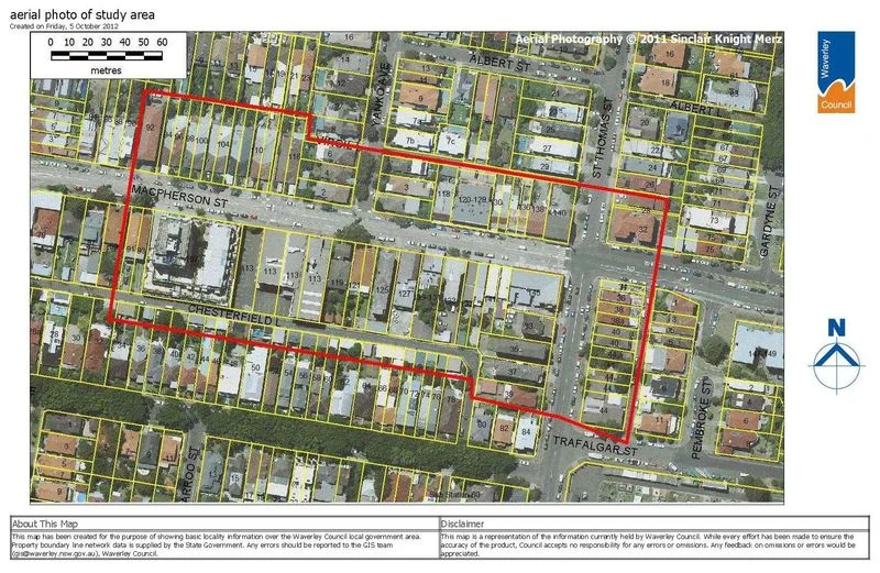
The Department of Planning and Environment (DP&E) approved Waverley Council’s Local Environment Plan (LEP) for the Macpherson and St Thomas Streets neighbourhood centre on 4 September 2014. A revised planning proposal for the Bronte RSL site has been referred to Waverley Council who will progress the proposal to exhibition for public feedback.
A Department spokesperson said the approved LEP reflects Council’s intention to maintain the Macpherson and St Thomas streets neighbourhood centre as a local scale centre serving the Bronte community.
“Council’s LEP as approved by the Department represents a balanced approach and provides certainty for the community and retailers by restricting the size of retail tenancies to 500 square metres,” the spokesperson said.
“The LEP has also been updated to recognise the RSL Club as an integral part of the local community.”
The retail cap is a marginal increase on Council’s original 400sqm proposed limit, and reflects both council officer recommendations and independent reports commissioned by council.
Other modifications made to the planning proposal are:
- Removing access to loading docks and residential parking from Chesterfield Lane
- Reducing building height on Chesterfield Lane from 3 to 2 storeys
- Increasing side set back to comply with local guidelines
- Reducing overall retail and commercial floor space
- Redesigning the Macpherson Street facade
For more information, please click here.
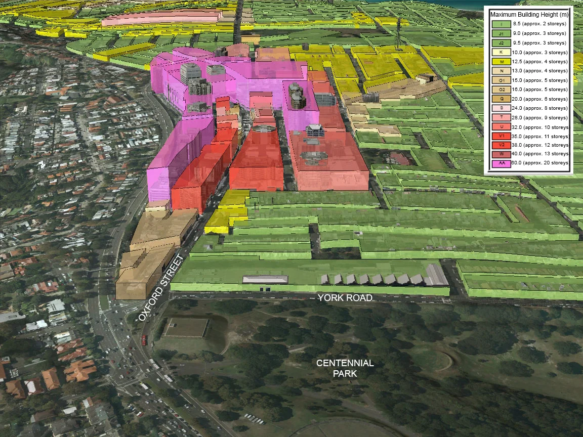
Waverley Council is currently working with the community, the NSW Government Architect's Office, businesses and landowners to develop a plan for the future of the West Oxford Street precinct, as part of a strategic approach to planning for the neighbourhood.
The report brings together the ideas developed by the three design teams who participated in the design charrettes and outlines preliminary short, medium and long-term opportunities for the area to:
- Make it more vibrant, pedestrian-friendly and green improve connections to the Bondi Junction centre and neighbouring Woollahra.
- Take a long-term approach to planning for the needs of the community.
Following the public exhibition period, all of the feedback and comments submitted will be collated and we will look at what ideas in the report should be considered for further testing and which ideas should be abandoned. A revised report will then be considered by Council late in 2014 for adoption.
For more information check out: http://haveyoursaywaverley.com.au/westoxford
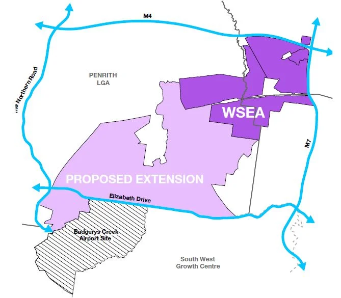
The Planning Minister Pru Goward announced on the 21 August 2014 that the NSW Liberal and Nationals Government are taking advantage of the Commonwealth’s plans for a second Sydney airport by expanding the footprint of the Western Sydney Employment Area (WSEA) to deliver even more jobs for Western Sydney.
The Western Sydney Employment Area is the area set aside for industrial and commercial purposes that is serviced by strong road links and infrastructure, and an expanded WSEA will exceed original job projections by delivering land for more than 57,000 jobs.
The proposed extension will increase the employment area boundary south to Elizabeth Drive and to include land west of the planned second Sydney airport, providing more than 4,500 additional hectares for economic growth in Western Sydney.

Waverley Council has revealed a staged concept master plan as part of the development of the Bondi Beach, Park and Pavilion Plan of Management.
Some of the concepts include: replacing the car park on Queen Elizabeth Drive with an underground car park to provide more green and recreation space, more trees and shade, a boardwalk, connection on the coastal walk, and opening up the back of the historic pavilion.
For more information go to Bondi Beach, Park and Pavilion Plan of Management

On 10 August the Minister for Planning Pru Goward announced a further 2,500 new Western Sydney home sites will be instantly unlocked, following changes to NSW Government planning policy. The changes to the Growth Centres State Environmental Planning Policy (SEPP) will deliver more housing choice and affordability in Western Sydney’s Growth Centres.
The changes to the Growth Centres State Environmental Planning Policy will allow:
- More housing choices in low density areas by permitting townhouse and villa-style housing, and allowing detached homes on a wider range of lot sizes, where there is good access to transport, shops or community facilities
- Detached dwellings on small lots in medium density zones, so that developers can offer a wider range of more compact housing options at the right price
- Studio dwellings to be strata subdivided from the main house so they can be sold separately
- Standardised minimum lot sizes that are related to minimum density controls
- Streamlined approval pathways to improve the feasibility of more diverse housing types, leading to reduced construction costs
- Standards for subdivision and house design to ensure attractive and liveable communities
- Increased opportunities for home buyers to utilise the Housing Code for 10 day approvals of new homes on smaller lots.
Further information on the Growth Centres planning changes can be found at:
http://growthcentres.planning.nsw.gov.au/
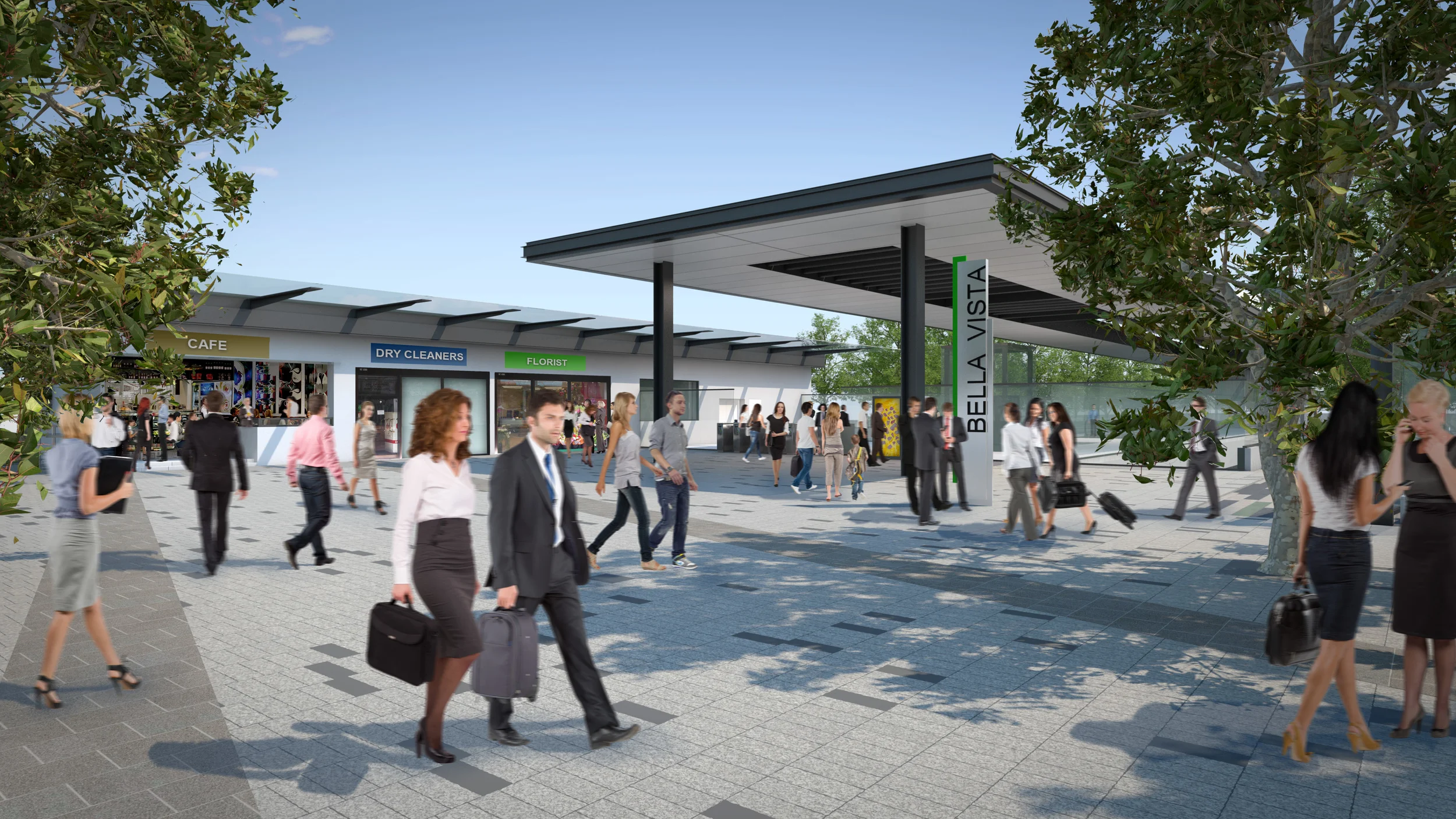
The Minister for Planning Pru Goward announced on 1 August 2014 that the NSW Government will partner with The Hills Shire Council and the community to create three new vibrant centres for homes and jobs along the $8.3 billion North West Rail Link, as part of a major urban renewal program.
The NSW Government will undertake detailed planning, investigations and consultation for three precincts around the new Bella Vista, Kellyville and Showground railway stations, now The Hills Shire Council has nominated them as Urban Activation Precincts.
Key features of the vision for the three new Urban Activation Precincts are:
- Bella Vista: A mixed employment and residential precinct with capacity for up to 4,400 additional homes and 10,500 jobs across 472 hectares. The precinct will build on existing office and warehouse space with shops, cafes and restaurants near the new station. Public parks and streets will be improved and Bella Vista Farm will remain a key conservation and heritage area.
- Kellyville: A vibrant, active centre focused around the new station providing greater choice for people with different housing needs. The precinct has capacity for up to 4,400 new homes and 800 jobs with the majority of new development proposed to be concentrated close to the new station. The precinct will feature conservation areas to protect endangered species, and enhanced walkways and cycle routes between the station and nearby centres.
- Showground: A vibrant mixed use precinct with shops, cafes, restaurants and new office buildings centred around the new station. The precinct has capacity for up to 3,600 new homes and 7,700 jobs across 271 hectares. A green corridor will be maintained around Cattai Creek and Castle Hill Showground will be upgraded as an essential recreational space for the community.

The Electronic Housing Code allows home owners, developers and business owners to electronically lodge a complying development application under the NSW Housing Code. You are also able to determine if you are able to proceed with your development without further approvals, as an exempt development.
See more details and access the Electronic Housing Code at:

The NSW Government has launched new ePlanning tools including an Interactive Buildings tool. This tool will allow users to click on an interactive 3D image model of a standard home, commercial or industrial property and understand in plain English what development standards apply and what work can be undertaken as exempt development.
The tool will provide easy access to information on minor home improvements, commercial and industrial projects.
More information and the Interactive Buildings tool can be found at:
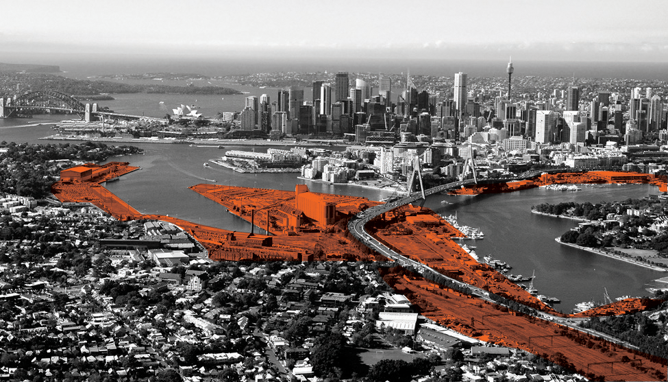
The Federal government has announced plans for a redevelopment of the Sydney Harbour Bays precinct.
The proposed development locations are: White Bay Power Station, Rozelle Rail Yards, Rozelle Bay and Blackwattle Bay, spanning a total development area of 80 hectares. The proposal includes a mix of residential, retail, tourism, commercial recreational and maritime use.
It is anticipated development will take 30 years to complete.
Full details can be found at:
http://www.shfa.nsw.gov.au/sydney-Our_places_and_projects-Our_projects-Bays_Precinct.htm
The NSW Government has launched the Planning Viewer beta program.
The Planning Viewer provides public access to the map layers for certain planning maps incorporated by reference in environmental planning instruments made under the Environmental Planning and Assessment Act 1979.
The Viewer is an initiative of the New South Wales Government and is designed to help people better understand map-based planning information. It enables users to search, navigate and view the map layers using standard map viewer functionality.
Planning Viewer can be found at:
https://maps.planningportal.nsw.gov.au/Terms?lga=6700&layers=LZN&level=13
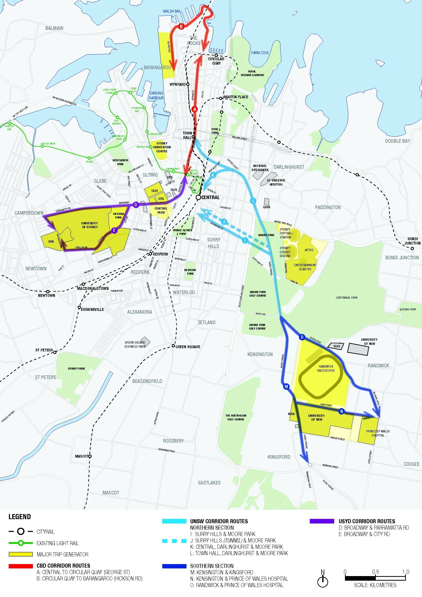
Planning approval has been granted for the $1.6 billion CBD and South East Light Rail project.
The 12 kilometre route includes 20 light rail stops and extends from Circular Quay along George Street to Central Station and Moore Park, then to Kingsford via Anzac Parade and Randwick via Alison Road and High Street.
It will link Circular Quay and Central, the Moore Park sporting and entertainment precinct including the Sydney Cricket Ground and Sydney Football Stadium, Randwick Racecourse, the University of NSW and Prince of Wales Hospital at Randwick.
The CBD Light Rail will be a high frequency service departing every two to three minutes during peak periods within the CBD.
Construction is expected to commence in 2015 with the new light rail service operating by 2020.
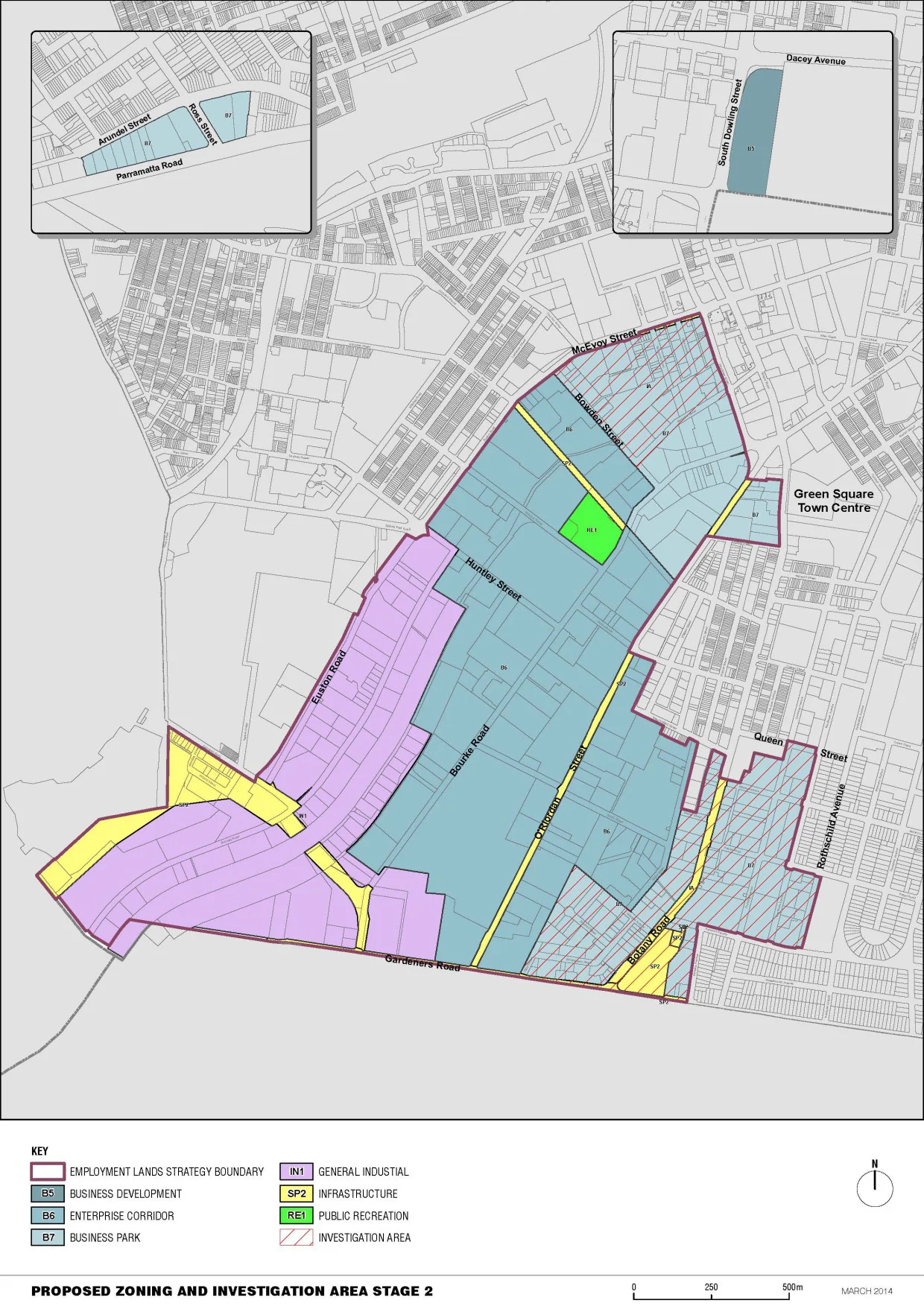
The recently released City of Sydney Employment Lands Strategy (strategy) is to guide growth and change to 2030 in the employment lands in the City of Sydney local government area (LGA).
The primary role of the employment lands is to facilitate new business and industry opportunities, provide employment across a range of sectors, and provide land for strategic industrial activity and essential urban services. The employment lands will continue to play a crucial role in supporting growth of the local, metropolitan, state and national economies whilst facilitating regional and global network connections.
The full strategy can be viewed at: